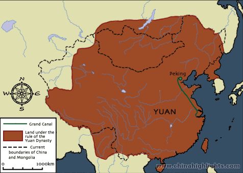
This is a map of the Yuan Dynasty. (1279-1368 CE) The brown area on the map is the land
under the rule of the Yuan Dynasty. The green line on the right side of the map is the Grand Canal. The Grand Canal was important because it made transportation easier by connecting north China to south China. The dashed lines are the current boundaries of China and Mongolia. The Yuan dynasty was a lot bigger then both combined because during the Yuan Dynasty, the Mongols controlled almost all of China which meant that the land under the rule of the Yuan Dynasty was greatly expanded. The capital is not on this map but it was Dadu but once Kublai Khan became emperor he changed it to Shangdu. Both cities were located a little north of the Grand Canal which made them convenient locations for transportation and trade.
Great info, but your sentence construction needs some work. Also, please edit.
ReplyDelete